Why Only the Northern Counties in Iowa?
Searching Early Maps for Clues
Surviving Ancient Trails in Iowa
What is it?
Almost all of Iowa’s existing roads postdate 1850. The familiar one-mile checkerboard of township roads replaced a far-older trail system established by Indians, traders, and soldiers before American settlement. Early explorers and the U.S. General Land Office (GLO) mapped some of these ancient trails.
Ancient trails typically followed natural routes dictated by topography and obstacles: running along ridge tops, curving around wetlands, winding down drainages to river bottoms where they crossed at natural fords. Despite the seeming disappearance of the pre-statehood trail system, some of these routes are still followed. They have evolved into field roads, gravel roads, or modern highways which still follow their original ancient routes.
Which modern roads have ancient origins? The Ancient Trails project analyzed old maps, aerial photographs, and high-resolution lidar topographic maps to determine the exact location and survival of ancient roads, using the northern half of Iowa as a test project.
A few of the longer surviving routes are converted into Ancient Trails Tour routes, where you can drive or bike along paths that existed before Iowa was a state. Some routes may have been used by Indians for centuries.
Why is this Important?
Beginning in the 1850s, Iowa began carving up the countryside into square-mile road sections, with little heed for topography or efficiency, causing the ancient trail system to largely disappear. Even now, the number of surviving ancient trails is decreasing, as old field roads are plowed to make larger fields, roads are straightened, and forest trails erode. The Ancient Trails study reveals that in northern Iowa only about 15% of these early trails survive in some recognizable form. Judging from old aerial photos, this is a decrease from the 1930s, when almost 18% of the early trails survived. Documenting the remaining ancient trails is necessary if any of it is to be preserved or appreciated.
Why Only the Northern Counties in Iowa?
This project targeted the northern 42 counties of Iowa, this is about 40 percent of the state. Northern Iowa is ideal for this study because it includes a wide range of historic trail types, from the military trails of Fort Atkinson, to mining trails around Dubuque, to the older Chemin des Voyageurs trails used by fur traders, to settler roads that connect to Fort Dodge. Northern Iowa also includes seven of Iowa’s 12 landform regions, from the picturesque Loess Hills in the west, to the swampy Des Moines Lobe in the center, to the almost mountainous Paleozoic Plateau in the northeast; this northern tier of counties provides a good example of the trail preservation potential across assorted regions. Finally this region was largely unsettled when GLO surveys were conducted, unlike the southern half of the state, meaning more of the trails are likely to be pre-settler in age.
Credits
This project was funded by the Transportation Alternatives Program, Office of Systems Planning, at the Iowa Department of Transportation. Bill Whittaker conducted archival research and writing, Angela Collins designed web pages, tours, and maps, and Angela Collins and Warren Davis conduced field research.
Searching Early Maps for Clues
Cartographers of the 1700s and early 1800s frequently depicted trails in early maps of the Americas. The Chemin des Voyageurs crossed what later became northern Iowa, connecting the Mississippi River with large Ioway, Otoe, and Omaha tribe villages in northwest Iowa along Spirit Lake and the Big Sioux River. Early trails ran up and down both sides of the Mississippi, and along the east side of the Des Moines River. The precise route of these earliest mapped trails is difficult to determine, but their general course is discernable.
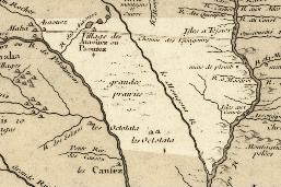 De L’Isle’s 1718 map. Approximate Iowa boundary shaded lighter. The Chemin des Voyageurs ran from the Mouth of the Wisconsin overland to Ioway villages near Spirit Lake to Ioway and Omaha villages near Blood Run in northwest Iowa. Other Indians shown in Iowa include the Otoe (Octotata). |
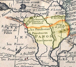 Chatelain’s 1719 map shows more early trails. In addition to the Ioway (Aiaouez and Paoute), Otoe (Octctata), and Omaha (Maha), the Pawnee (Panos/Panibousa) are shown in Iowa. Approximate Iowa boundary shaded yellow, trails outlined in red. |
 Jefferys’s 1776 map showing the “French Route to the Western Indians” across Iowa, from the mouth of the Wisconsin to Spirit Lake to Blood Run. Approximate Iowa boundary shaded yellow, trails outlined in red. |
No Heart’s 1837 Map
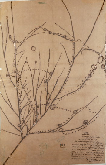 |
The Ioway map, presented to the U.S. government in 1837 by Chief No Heart, shows the movement of the Ioway the late 1700s and early 1800s. This map is remarkable because it is the only Native-made map of Iowa in the 1800s. Although this map shows dotted lines that appear to be trails, they actually show the sequence of tribal movement across the landscape. Research shows that No Heart’s map, unfortunately, is not useful for pinpointing village locations. In some instances, No Heart’s dotted lines may represent actual trails, as there is some correlation with trails mapped by explorers in the 1700s and early 1800s, but there is no clear link to the GLO trails mapped in the later 1800s.
No Heart’s Ioway map, 1837. Main line from bottom left corner to top center is the Mississippi River, major vertical line on left side is Missouri River. |
Surviving Ancient Trails in Iowa
|
Example of old wagon ruts |
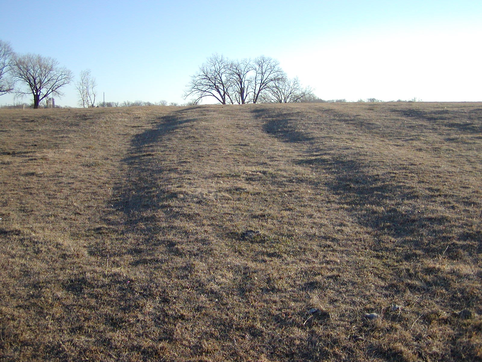
Example of an old road cut in northeastern Iowa, identified during project field verification |
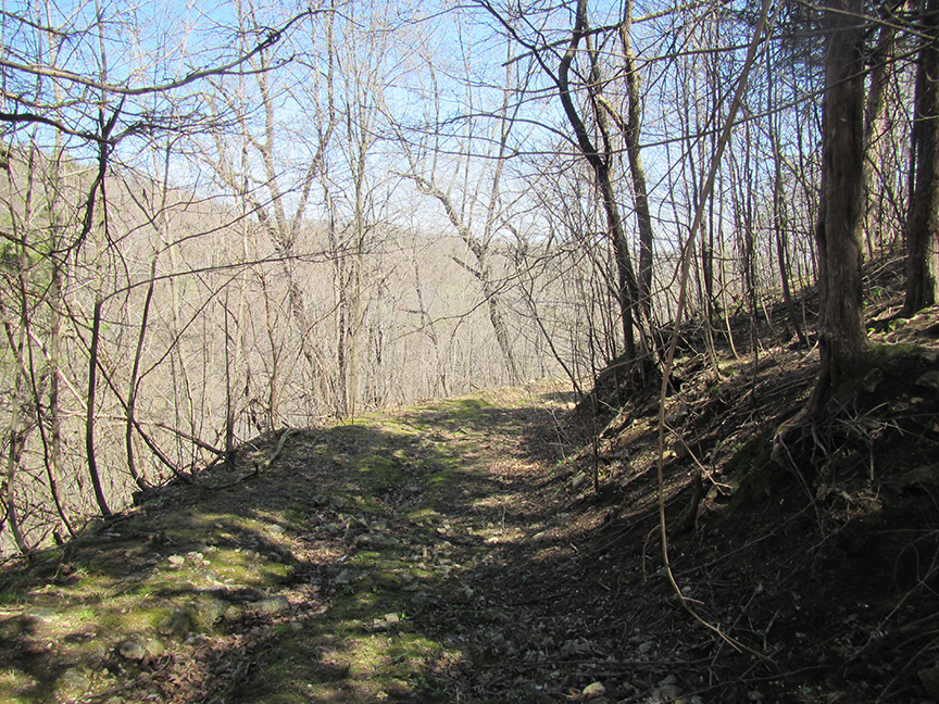
Between 1833 and 1861, the General Land Office (GLO) mapped 6,830 miles of trails in Iowa prior to the U.S. government sale of the land to mostly Euro-American settlers. The northern 42 counties of Iowa contained 437 trails measuring 1,590 miles. Analysis of aerial photos, old maps, and high-resolution lidar topographic maps reveal that only about 15% of these trails survive. Many of these survivors are private field roads, but some align with public roads and streets. Here we present eight Ancient Trails Tours that follow old routes.
| < Ancient Trails Tours Home | Tour 1 > |