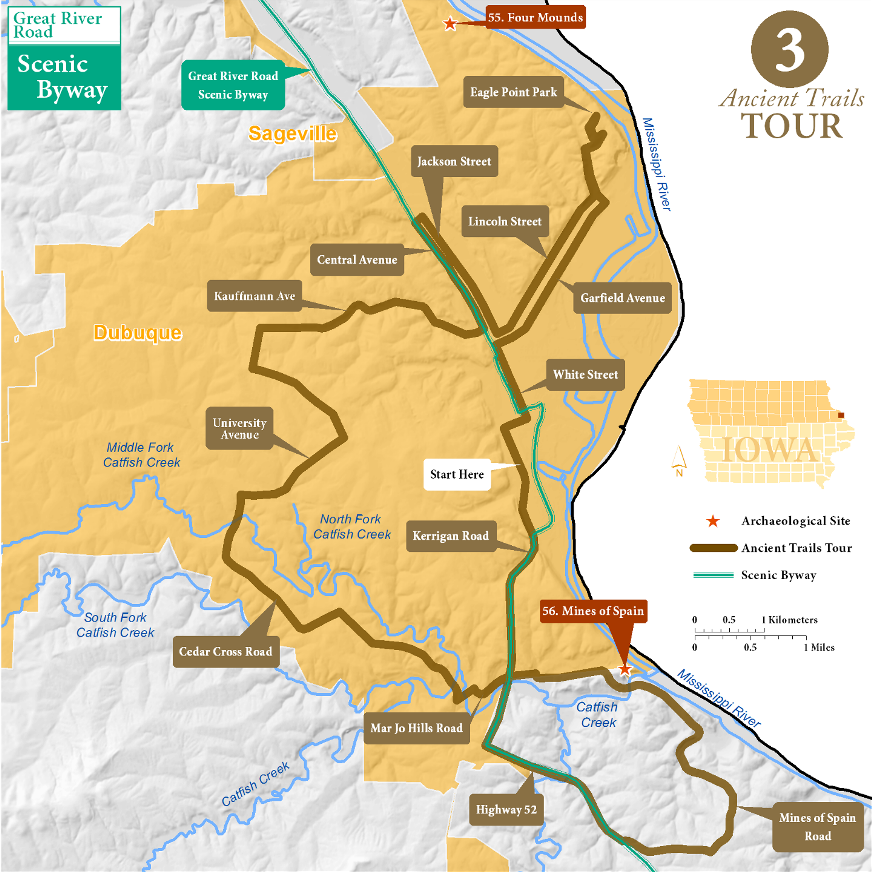
Dubuque Loop Tour
At the beginning of the 1800s Julien Dubuque had a large claim on lead-mining lands near what is now his namesake town (56 in the Archaeological Guide to Iowa). He worked as a liaison between the Meskwaki mining in the territory and the French and Spanish traders and administrators in St. Louis. Prehistorically and historically, Indians lived throughout the Dubuque region, building mounds on the bluffs and maintaining large villages below. Dubuque became an entrepôt for American settlers beginning in 1830, when the Meskwaki were illegally forced to move west.
Downtown to Eagle Point Park (7 miles)
Heading north on Locust to W. 8th Street you drive through what was a Meskwaki Village in the early 1800s. An 1820s trading post was near Locust and 2nd, and early settlers reported Meskwaki cemeteries along Main Street. Turn right on 8th and left on White, at this intersection is the 1858 jail, its predecessor was used to incarcerate Indians accused of crimes at Fort Atkinson. Turn right on E. 30th and continue onto Garfield. This was an old GLO trail which led to a second historic Indian village; there were also as many as 70 Indian mounds in this part of town, all likely destroyed as the city expanded. Turn left on Shiras Avenue, and stop off at the Ham House Museum for early Iowa exhibits. Head up the bluff to Eagle Point Park, where you can see the buildings and landscaping of the renowned architect Alfred Caldwell. There used to be numerous Indian mounds at the south end of the park, but they have long since been destroyed. Enjoy the view, and return the way you came, taking Lincoln Avenue to Jackson.
Couler Valley and Lead Mining Hills (12 miles)
Turn right (northwest) on Jackson, and follow it up the Couler Valley, which was a main entry into the interior of Iowa for settlers in the 1840s and 1850s. At E. 32nd Street the old trails split, and travelers could continue north along Central or northeast along E. 32nd/Peru. Come back to town along Central, and you can follow a curving loop of ancient trails that ran past the locations of Indian and settler lead mines in the hills. Kaufmann Avenue was mapped in the 1830s, despite its modern appearance. At Carter Road head south and take a left on Asbury and a right on University, and you will closely follow old trails. From here, you can wind through suburban streets which look like they are new, but follow the rough course of trails that are at least 170 years old: Cedar Cross to Fremont to Kelly to Old Mill to Rockdale to Mar Jo Hills and finally to Mines of Spain.
Mines of Spain (7 miles)
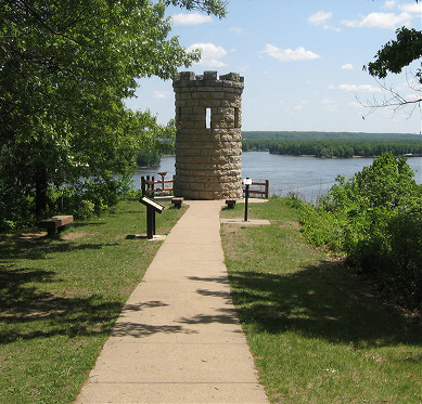
Julien Dubuque is buried at the end of the bluff, his log mausoleum built by the Meskwaki was replaced in the late 1800s by a large castle-like tower. Nearby are the marked graves of important Meskwaki leaders. Follow Mines of Spain road to the bluffs to the south, where you will overlook the former location of a large Meskwaki village and wind through hills pockmarked with old mine diggings. Olde Massey will take you back to U.S. 52. Take U.S. 151 north to return to downtown Dubuque.
Great River Road Scenic Byway

The Great River Road Scenic Byway runs through this ancient trails tour. Click here for more about the byway.
Archaeological Sites
55. Four Mounds

Along the bluff edge on the far north side of Dubuque, four low prehistoric mounds remain. Their survival is an accident; their were built on a bluff ridge that was too narrow to far, so they were spared the most common fate of mounds, the slow erosion under steel blades. The mounds were listed on the National Register of Historic Places in 2000.
To Visit
The nicely preserved mounds are now located on the ground of the Four Mounds Inn & Conference Center, located at 4900 Peru Road in Dubuque (563-556-1908), https://www.fourmounds.org/.
You can also visit the Little Maquoketa River Mounds State Preserve just north of Sageville where you can hike the trails amid prehistoric mounds and take in the spectacular vista overlooking the Little Maqoketa River.
56. Mines of Spain
The area just south of Dubuque contains the densest concentration of archaeological sites in Iowa, totaling more than 250 in a 3-mile stretch along the Mississippi River.
The Meskwaki occupied the area and established a large village, probably in the 1770s. Julien Dubuque, among the first Europeans to settle in what is now Iowa, got along well with the Meskwaki, and they gave him permission to live and mine lead in the area. Dubuque employed the Meskwaki and acted as a financial intermediary, converting mined lead into trade goods through his connections in St. Louis. Lead continued to be mined in this area until the Civil War.
Archaeologists, despite numerous attempts, have not been able to find remnants of the Meskwaki village. When Dubuque died, the Meskwaki buried him in a log cabin tomb, a traditional ritual for their leaders. By the end of the century, though, this tomb was dilapidated. In 1897, local residents built a stone tower on the bluff to mark the gravesite. The Mines of Spain region is listed as a National Historic Landmark and a state preserve.
To Visit
Much of this region is now part of the Mines of Spain Recreation Area, which runs the E. B. Lyons Interpretive Center, 8991 Bellevie Heights, Dubuque, near the intersection of U.S. Highways 52 and 61. It is open Monday-Friday, year-round, and on weekends April-October (563-556-0620).