Upper Iowa River Tour
Allamakee County contains some of the most beautiful landscape in the Midwest, with steep, almost mountainous topography, forest, pastures, and roiling streams. This tour takes you along the Upper Iowa River and Village Creek.
Lansing to the Upper Iowa River along the Mississippi (10 miles)
If you start in Lansing and head north along the Great River Road, you will be following one of the oldest superhighways; the trail along the Mississippi was mapped as early as 1763, but was likely used for hundreds or thousands of years before that. It was often easier to walk up the river along the bank than it was to paddle upstream. Lansing was the location of a Ho-Chunk (Winnebago) village in the 1840s and 1850s. On your way north, stop off at the Fish Farm Mound Group (44 in the Archaeological Guide to Iowa). This segment is also part of the Driftless Scenic Byway.
Up the Upper Iowa River (7 miles)
Follow Iowa River Drive west. The Chemin Des Voyageurs trail connected the Mississippi valley with large Indian villages in western Iowa. The earliest mapped Chemin depictions began along the Upper Iowa River where numerous huge fortified villages lined the bluffs and terraces along the river. The ancestors of the Ioway and Ho-Chunk (Winnebago) lived here at the time of European contact (43 in the Archaeological Guide to Iowa). The huge, castle-like cliffs suggest why this area was chosen for defensive positions. As the Ioway dispersed west and Ho-Chunk east, the region became the center of Dakota villages, visited by numerous European explorers and traders; by the 1830s the Ho-Chunk returned to the valley. The river is steeped in the history of Sauk Indians as well; in 1832 man in Black Hawk’s band were massacred near the mouth of the Iowa as they tried to cross the Mississippi. This segment is also part of the Driftless Scenic Byway.
Overland to Village Creek (13 miles)
Head south on Lycurgus Road, which follows an upland ridge trail mapped by the GLO. Ridge-top trails were likely faster, since the tops of ridges tend to be more level and it was easier to travel in a straight line. Trails along rivers tend to wind with the river and face many topographic obstacles. A disadvantage to upland trails is that they leave the traveler exposed, both to the elements and enemies, and they have fewer places to hunt game or collect plant food. Head east on State Highway 9, and descend down the bluff into Village Creek by heading south on Village Creek Road.
Village Creek to Lansing (11 miles)
Village Creek is little sister to the Upper Iowa River, with imposing bluffs and mountainous landscapes. The original trail along Village Creek mapped by the GLO went up and down the bluffs, the modern road is much smoother. GLO surveyors noted a recently abandoned Indian village in 1849 about 9 miles above the mouth of the river. “Old Indian village, about 1/2 dozen lodges” was their notation. Archaeology suggests there was an older historic Indian village near the mouth of the river, where historic European trade goods were excavated at an Indian site.
Driftless Scenic Byway

Much of the Upper Iowa Loop Ancient Trails Tour includes portions of the Driftless Scenic Byway. Click here for more about the byway.
Archaeological Sites
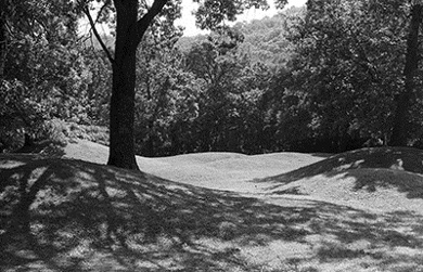
44. Fish Farm Mounds
Fish Farm Mounds, a cluster of 30 conical mounds, sit on a high alluvial terrace above the Mississippi floodplain at the northeast corner of Allamakee County. Twenty-eight mounds within this group were dedicated in 1968 as one of Iowa's very first state preserves.
To Visit
A small cluster of mounds in Harpers Ferry can be found of the south side of town, where an old cemetery shelters seven mounds. The cemetery is at the south end of Sandy Point Road, just south of some condominiums, along the river bank. These mounds have historical graves dug into them, which is probably why they were spared destruction.
43. Upper Iowa Tour
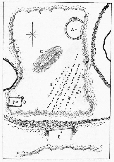
Ancient enclosures along the Upper Iowa River were constructed during the Late Prehistoric period, beginning about 1,000 years ago. No longer moving across the landscape utilizing wild resources, people needed to protect their villages, defend their territory, and define who belonged. Researchers have found 11 possible enclosures in this area, but probably more once existed and have since been destroyed. Most enclosures were circular or oval but some were also rectangle. All enclosured showed evidence of ditches and some also had embankments.
To Visit
While the ancient enclosure sites are privately owned, driving along Iowa River Drive gives you a sense of the stunning landscape they occupied. Begin your tour here, and head west on Iowa River along Ancient Trail Tour 1.